

Big Bus San Francisco vs City Sightseeing: Route Networks and Golden Gate Approaches
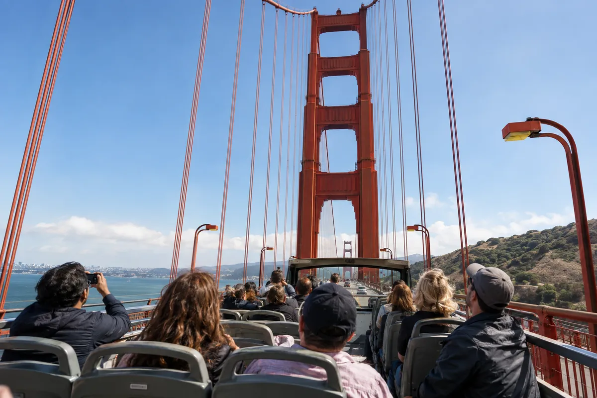
Crossing the Golden Gate strait on the open upper deck of a double-decker bus is the central reason most visitors buy a sightseeing pass in Northern California. In evaluating Big Bus San Francisco vs City Sightseeing SF, the differences in how each carrier approaches the bridge span, handles passenger queues, and negotiates ocean winds become apparent within the first hour on the road.
Both operators run their primary city circuits through the northern waterfront, but their terminal dispatching, stop spacing, and approach corridors diverge significantly once buses clear the Marina district. Understanding how these systems function before arriving at the waterfront prevents wasted hours standing on windy street corners.
Daytime Loop Configurations, Bridge Routing, and Departure Hubs
Big Bus Tours San Francisco operates its core Red Route as a 17-stop loop beginning at Fisherman's Wharf Stop 1, located at 99 Jefferson Street. Scheduled departures run daily between 10:00 AM and 5:00 PM, with the full circuit without disembarking taking approximately 2 hours. The route navigates through the Financial District and Union Square before steering westward toward the Presidio and across the Golden Gate Bridge into Marin County.
City Sightseeing San Francisco, operated locally under the Skyline Sightseeing umbrella, runs an 18-stop daylight circuit operating daily between 10:15 AM and 5:30 PM. Their buses depart primarily from hubs at 99 Jefferson Street and 2724 Taylor Street in Fisherman's Wharf. Both services merge onto the US-101 corridor via Richardson Avenue and Doyle Drive, climbing toward the southern bridge toll plaza before making the 1.7-mile crossing across the strait.
| Feature | Big Bus Red Route | City Sightseeing SF (Skyline) |
|---|---|---|
| Departure Terminal | 99 Jefferson St (Fisherman's Wharf) | 99 Jefferson St & 2724 Taylor St |
| Hours of Operation | 10:00 AM – 5:00 PM daily | 10:15 AM – 5:30 PM daily |
| Total Loop Stops | 17 designated stops | 18 designated stops |
| Full Circuit Duration | 2 hours (approx.) | 2 to 2.5 hours (traffic dependent) |
| Bridge Vista Stops | South Vista (Stop 11) & North Vista (Stop 12) | North Vista Point (Marin County) |
Between 10:00 AM and 11:30 AM, terminal queues at 99 Jefferson Street swell as hotel crowds arrive simultaneously. Securing an open-top front or middle seat requires boarding at least twenty minutes prior to scheduled departure.
Fleet Infrastructure, Upper-Deck Viewing, and Physical Accessibility
The open-top double-decker bus models deployed across both fleets feature traditional British and European chassis modified for North American transit clearance. The upper deck provides unobstructed 360-degree sightlines upward toward the 746-foot suspension towers. However, city regulations strictly mandate that all passengers remain seated while the vehicle is in motion to prevent severe head and neck injuries from low-hanging Muni trolley electric cables and roadside tree canopies.
Accessibility presents a distinct physical divide between vehicle levels. Wheelchair access on Big Bus San Francisco is restricted to the enclosed lower deck via a fold-out mechanical boarding ramp. Lower-deck seating features tinted side glass and a low ceiling edge that cuts off upward angles toward the bridge cables, denying wheelchair users the sweeping aerial perspectives available above. Collapsible strollers and small prams are accepted on both carriers but must be folded entirely and stowed in lower-deck luggage bays before boarding.
If riding the upper deck, choose seats on the starboard (right-hand) side for the northbound crossing. This orientation keeps your view focused on Alcatraz, the downtown skyline, and the open bay without looking across oncoming highway lanes.
Big Bus SF Golden Gate Review: Vista Points, Wind Realities, and Pedestrian Walks
The operational divide between major san francisco hop on bus operators becomes critical once the vehicles enter the bridge approaches. In my tests of both lines across varying weather conditions, how each carrier manages vista point access directly dictates whether passengers get photograph opportunities or spend their afternoon waiting in exhaust fumes.
A rigorous big bus sf golden gate review requires analyzing the physical terrain of both bridge abutments. Big Bus remains the only commercial hop-on provider offering dedicated boarding facilities on both sides of the suspension span.
South Vista Point vs North Vista Point Disembarkation Mechanics
Big Bus features two separate bridge stops along the Red Route: Stop 11 at South Vista Point adjacent to the Golden Gate Bridge Welcome Center, and Stop 12 across the span at North Vista Point in Marin County. This dual-stop layout allows passengers to disembark on the San Francisco bluff, browse the visitor pavilion exhibits, take photos of the southern anchorage, and catch a later bus across the water. City Sightseeing bypasses the southern parking complex entirely, carrying passengers directly across the bridge into Marin County.
At North Vista Point, Big Bus riders can step off into the public observation plaza to capture head-on panoramas of the San Francisco skyline framed beneath the bridge cables. Buses then loop the parking turnaround and head south back into the city toward the Palace of Fine Arts stop. However, because hop-on hop-off tickets do not reserve individual seats, North Vista Point poses a severe bottleneck on sunny weekend afternoons when returning buses frequently arrive already filled with passengers.
The final Big Bus daytime departure leaves Fisherman's Wharf at 5:00 PM and clears North Vista Point between 5:45 PM and 6:00 PM. Missing this final bus strands you in Marin County with no tour operator return service.
Microclimate Drops, Marine Layers, and Top-Deck Survival Strategies
San Francisco's summer climate is famously deceptive, and the Golden Gate strait functions as a high-velocity wind tunnel pulling frigid Pacific air into the warmer Central Valley. Upper-deck temperatures crossing the span frequently drop 15°F to 20°F (8°C to 11°C) lower than downtown San Francisco. Ocean gales regularly gust between 25 and 40 mph mid-span, turning mild city days into freezing open-air rides.
When Karl the Fog rolls through the Golden Gate, visibility on the upper deck drops to near zero, soaking unprotected passengers in damp mist. Proper preparation requires a windproof jacket with a secure hood, fleece layering, and zippered pockets. Unsecured baseball caps, loose scarves, and handheld phones without wrist leashes are routinely blown overboard by sudden crosswinds while crossing the center span.
Top-deck seating strategy: If the lower deck is full and you are sensitive to heavy wind chill, sit directly behind the solid front windscreen on the upper deck. It deflects the brunt of the headwind while keeping open upward sightlines toward the towers.
Self-Guided Span Crossing: South-to-North Pedestrian Walk Integration
The dual-stop configuration of Big Bus enables a practical self-guided bridge pedestrian walkway walk. You can hop off at Stop 11 (South Vista Point), pass through the visitor plaza, and walk the entire 1.7-mile (2.7 km) suspension span across the East Sidewalk into Marin County. The walk takes roughly 35 to 45 minutes at a steady pace and allows you to experience the bridge's structural vibration and maritime views firsthand before re-boarding at Stop 12 (North Vista Point).
Access to the Golden Gate Bridge East Sidewalk is free of charge for pedestrians, with automated security gates open daily from 5:00 AM to 6:30 PM Pacific Standard Time, extending until 9:00 PM during daylight saving time per the Golden Gate Bridge District sidewalk regulations. Before attempting this walk, be aware of cycling traffic rules: on weekdays before 3:30 PM, cyclists share the East Sidewalk with pedestrians, creating crowded pinch points around the suspension towers. After 3:30 PM on weekdays, and all day on weekends and holidays, cyclists are diverted to the West Sidewalk, leaving the eastern walkway clear for foot traffic.
Onboard Technology, Narration Quality, and Dispatch Tracking
A successful sightseeing circuit depends heavily on route pacing and communication. As detailed in our comprehensive San Francisco hop-on hop-off bus guide, navigating the city's steep grid and bridge bottlenecks requires dependable real-time dispatching and clear commentary.
When comparing Big Bus and City Sightseeing, the choice comes down to digital consistency versus the unpredictable charm of live narration. Each approach carries distinct operational trade-offs depending on traffic density and language preference.
GPS-Triggered Audio Narration vs Live Onboard Guides
Big Bus equips its double-decker fleet with pre-recorded digital audio commentary synchronized to the vehicle's real-time geographic position. Delivered through complimentary 3.5mm earbuds distributed upon boarding, the narration is available in eight languages. The automated system triggers historical explanations based on specific waypoints, detailing the construction of the suspension towers and the geology of the Marin Headlands as the bus approaches the span.
City Sightseeing SF, through its local Skyline Sightseeing operation, frequently places live English-speaking guides on the microphone, supplemented by a downloadable smartphone audio application for foreign language commentary. When an onboard guide is knowledgeable and attentive, the experience is engaging and responsive to passing street scenes. However, audio clarity varies depending on bus speaker maintenance, and guide delivery can become repetitive during prolonged traffic jams on Lombard Street.
Real-Time Bus Tracking vs Scheduled Headway Reliability
Live vehicle tracking is an essential tool when waiting at remote locations like North Vista Point. The Big Bus mobile app integrates live GPS bus tracking with interactive route maps, displaying active bus positions and countdown estimated arrival times for every designated stop. City Sightseeing relies primarily on scheduled headway intervals ranging from 25 to 60 minutes, lacking responsive live-map telemetry inside their standard customer interface.
Big Bus maintains daytime headways of 15 to 20 minutes during high summer season, relaxing to 30-minute intervals during off-peak weekday periods. In my tracking tests, the Big Bus app provided dependable guidance across downtown, though arrival estimates can freeze temporarily when buses enter gridlock along the Presidio Parkway approach corridor. Knowing where the next bus is located prevents unnecessary standing on windy coastal platforms.
Consult our guide to top-deck seating and weather preparation for detailed tactics on how to manage app tracking, connection buffers, and battery drainage in cold coastal environments.
Route Pacing, Stop Dwell Times, and Traffic Bottlenecks
Traffic patterns in northern San Francisco heavily impact scheduled tour loops. The advertised 2-hour loop time on the Big Bus Red Route regularly stretches to 2 hours and 30 minutes on weekend afternoons due to street congestion. Primary bottlenecks occur along the US-101 Richardson Avenue corridor, where cross-town traffic merges toward the bridge approaches, and along Marina Boulevard due to heavy tourist foot traffic near the Palace of Fine Arts stop.
Stop dwell times also skew bus spacing. At major passenger interchanges like Fisherman's Wharf Stop 1 and Pier 39, loading dozens of ticket holders through single-door validators can take up to ten minutes per vehicle. These prolonged station stops cause buses to bunch together, resulting in forty-minute gaps followed by two buses arriving back-to-back at the bridge vista points.
Ticket Tiers, Route Limits, and the Sausalito Extension Reality
Hop-on hop-off ticketing in San Francisco involves multiple tiers, validation rules, and territorial restrictions that are often obscured in standard sales brochures. Evaluating the value of these passes requires analyzing exactly what is included in the daytime loop versus add-on excursions.
Both major operators structure their standard passes around calendar-day or hourly durations, with price differentials reflecting vehicle fleet quality and dispatch frequency. Understanding these boundaries helps prevent paying for excursions you cannot use.
2026 Price Structures, Multi-Day Passes, and Age Breakpoints
As of 2026, Big Bus 24-hour Discover tickets for adults are priced online at $56.10, discounted from the walk-up list price of $66.00. Child passes for ages 3 to 12 cost $47.60 online (standard $56.00), while infants aged 2 and under ride free of charge without requiring an allocated seat. The 48-hour Essential pass costs $63.75 online (standard $75.00) and bundles an evening tour, while the 72-hour Explore ticket runs $76.50 online (standard $90.00) and includes a 60-minute San Francisco Bay cruise.
City Sightseeing SF offers a lower entry point for daylight touring. Their standard 1-day adult hop-on hop-off pass is priced online at $46.75, compared to a $55.00 walk-up rate. Child tickets for ages 5 to 11 are priced at approximately $35.00. While City Sightseeing delivers an immediate $9.35 adult savings over Big Bus, its longer headways and less consistent dispatch tracking can offset the financial advantage for travelers on tight daily itineraries.
| Ticket Tier (Adult Online Rates) | Big Bus Tours SF | City Sightseeing SF | Primary Inclusions |
|---|---|---|---|
| 1-Day / 24-Hour Pass | $56.10 | $46.75 | Standard daytime city & bridge hop-on loop |
| 48-Hour Multi-Day Pass | $63.75 | Available as bundle | Extended loop access + Sunset/Night tour |
| 72-Hour Multi-Day Pass | $76.50 | Varies by package | Extended hop-on loop + Bay cruise add-on |
| Child Age Policy | Ages 3–12 ($47.60; ≤2 free) | Ages 5–11 ($35.00; ≤4 free) | Lower age thresholds for free infant travel |
Night Tours and Add-On Excursions: The Bay Bridge Misconception
A frequent misconception among international visitors is that panoramic evening and sunset bus tours cross the Golden Gate Bridge under floodlights. Neither Big Bus nor City Sightseeing routes its evening excursions across the Golden Gate span. Fog conditions, high crosswinds, and restricted vista point parking after dark make nighttime Golden Gate bus runs unfeasible.
Instead, the evening Bay Bridge sunset tour included with premium tickets departs downtown San Francisco, traverses the double-deck San Francisco-Oakland Bay Bridge (Interstate 80), and pulls into Treasure Island. This routing delivers panoramic views of the illuminated downtown skyline across the water. Daytime bridge crossing remains strictly limited to standard daytime loops.
The Sausalito Connector: Drop-Off Realities and Turnback Points
Promotional descriptions occasionally blur the distinction between crossing the Golden Gate Bridge and visiting Marin County towns. Neither Big Bus nor City Sightseeing provides downtown street drop-offs in Sausalito on their standard hop-on hop-off daytime loops. Buses cross the bridge span, loop the turnaround circle at North Vista Point, and immediately enter the southbound highway lanes back to San Francisco.
Attempting to walk from North Vista Point into downtown Sausalito is dangerous. The distance along Alexander Avenue is 2.2 miles (3.5 km) down steep hillside curves without a continuous pedestrian sidewalk. Pedestrians must walk alongside high-speed highway traffic on narrow road shoulders. Reaching Sausalito requires transferring to dedicated public transit or commercial ferry links rather than walking from the vista stop.
Do not attempt to walk down Alexander Avenue from North Vista Point to Sausalito. The roadway lacks continuous pedestrian sidewalks, features blind curves with fast vehicular traffic, and is unsafe for pedestrians.
Tour Buses vs DIY Public Transit: The Weekend Parking Advantage
Before purchasing an open-top bus tour, travelers frequently weigh the service against renting a passenger car or riding municipal buses. Comparing these choices reveals distinct operational advantages during peak holiday windows.
While commercial hop-on buses cost significantly more than city commuter services, their guaranteed parking access at scenic overlooks provides substantial utility when private vehicles are barred from the bluffs.
Weekend Parking Bans and North Vista Point Vehicle Restrictions
To curb severe highway congestion, the Golden Gate Bridge District enforces strict weekend parking restriction rules. Private passenger vehicles and rental cars are barred from parking at the North Vista Point and South Welcome Center lots on weekends and federal holidays between 11:00 AM and 5:00 PM. Law enforcement officers actively turn away private vehicles, leaving self-drive visitors unable to stop at the overlooks.
Tour buses operate under authorized commercial permits, granting them access to dedicated loading stalls throughout the weekend parking closure windows. Furthermore, self-drive rental cars crossing southbound into San Francisco face all-electronic tolls of $10.25 via FasTrak, $10.50 via Pay-As-You-Go, or $11.25 via Toll Invoice per the Golden Gate Bridge toll schedules. Rental agencies frequently add daily convenience fees ranging from $4.95 to $9.99 on top of the bridge toll, making private vehicle excursions financially inefficient compared to tour buses.
Golden Gate Transit Route 130 and the Clipper Card Public Transit Alternative
Travelers prioritizing transportation over sightseeing commentary can utilize regional public transit via Golden Gate Transit route 130. This commuter service connects central San Francisco directly to the Golden Gate Bridge toll plaza, North Vista Point, and downtown Sausalito. The single-deck commuter buses lack open-top decks and guided narratives, but run on precise schedules throughout the week.
As of the July 1, 2026 tariff schedule published in the Golden Gate Transit fare regulations, an adult one-way fare between San Francisco and Marin County costs $9.00 cash or $7.20 using a contactless payment card or Clipper card public transit alternative. A round-trip crossing costs $14.40 via contactless tap, offering massive savings compared to a $56.10 hop-on ticket. However, commuter bus windows are tinted and fixed, precluding high-angle bridge photography.
Our detailed breakdown in the comparison of major global hop-on hop-off bus operators examines how local public transit fares systematically stack up against open-top tour passes across high-cost cities.
Final Verdict: Choosing the Best Tour Bus in San Francisco for Bridge Crossings
Selecting the best tour bus san francisco experience depends on how you value photographic flexibility, operational predictability, and tour narrative style. Both major carriers complete the bridge crossing, but their execution addresses different travel priorities.
If your primary goal is capturing bridge photography and walking the span, Big Bus is the operationally superior carrier due to its South and North Vista Point stops. If minimizing upfront travel expenses is your sole requirement, City Sightseeing provides an affordable open-top crossing at a ten-dollar discount.
Head-to-Head Evaluation Matrix Across Traveler Profiles
To determine the most suitable carrier for your day on the bay, review this operational breakdown based on observed fleet performance and schedule adherence:
- Best for Vista Photography & Span Walkers: Big Bus. The exclusive dual-stop layout (Stop 11 South Vista and Stop 12 North Vista) allows you to walk across the bridge span on foot and re-board on the opposite bluff without buying extra transit passes.
- Best for Budget Sightseers: City Sightseeing SF. With adult advance tickets starting at $46.75 versus $56.10 for Big Bus, it delivers the lowest per-day price for an open-top bridge crossing.
- Best for Non-English Speakers: Big Bus. Pre-recorded GPS audio commentary in eight languages provides reliable, well-timed historical narration through complimentary earbuds without language barriers.
- Best for Live Anecdotes: City Sightseeing SF. Live onboard English-speaking tour guides share local commentary and neighborhood context, though presentation quality varies across drivers and guides.
- Best for Dispatch Predictability: Big Bus. Live GPS bus tracking within the mobile application eliminates guesswork at cold, exposed stops like North Vista Point.
Final Logistical Recommendations and Booking Strategy
To maximize your Golden Gate Bridge crossing, check real-time visibility conditions before heading to the waterfront. Marine fog can completely obscure the bridge towers while downtown streets remain clear. Monitor live weather and camera feeds via the Golden Gate Bridge current weather conditions portal prior to boarding.
Book your passes online at least 24 hours in advance to secure the standard 15% digital discount over gate rates. Aim to board at Stop 1 at Fisherman's Wharf before 10:30 AM to secure upper-deck seating ahead of midday crowds, and pack a windproof jacket to handle the severe temperature drop crossing the strait.